Digging Deep: What Lies Beneath Our Feet?
If you live in Northwestern Ontario, you know our landscape is defined by the Canadian Shield. Whether you are in Melgund Township, Borups Corners, or Dyment, the rock under our feet feels permanent and unshakeable. But as the Nuclear Waste Management Organization (NWMO) proposes the Revell Site for a Deep Geological Repository (DGR), we need to ask: is that rock actually solid enough to hold nuclear waste for thousands of years?
The latest technical documents describe the geology of our area, specifically the “Revell batholith.” We are taking a closer look at what the scientists are saying, and more importantly, what they are still guessing at.
What We Are Learning
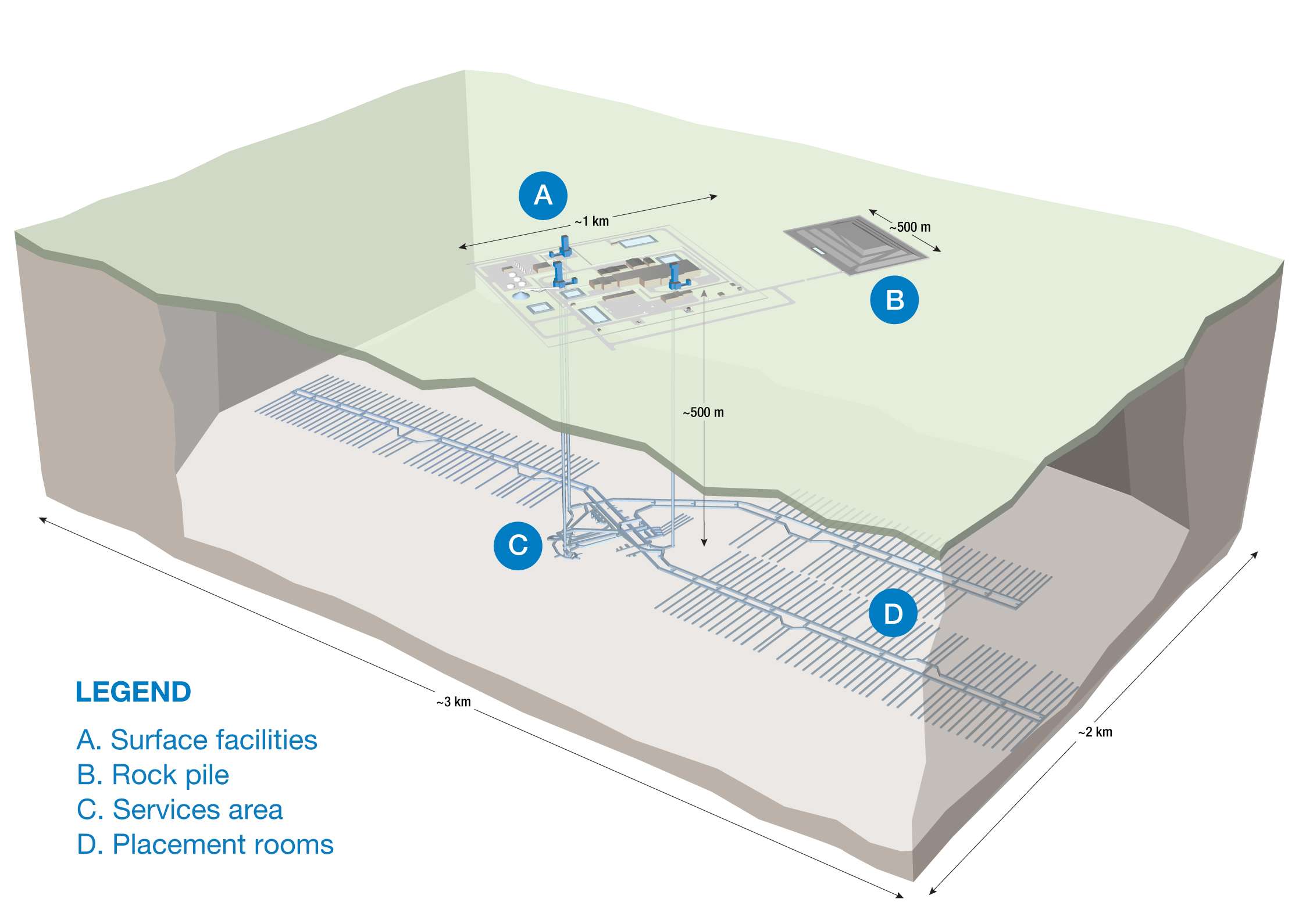
According to the NWMO’s initial project description, the Revell Site sits on a massive block of granite-like rock called a batholith. This rock formed about 2.7 billion years ago when magma cooled deep underground. The report suggests this rock is generally uniform (homogeneous) and extends nearly 4 kilometers deep.
The plan is to bury the waste about 750 meters down. The NWMO has drilled six deep boreholes in the area so far, reaching depths of 1 kilometer, to check the rock quality. They claim the rock is solid and that they can build the repository safely between any major cracks or “fracture zones.”
The Reality Check
While the description sounds reassuring, a closer look at the Impact Assessment data reveals some gaps between what is promised and what has been proven.
- What is Promised: The repository will be safely positioned between “inferred” fracture zones to ensure containment.
- What We Need to Verify: The word “inferred” is doing a lot of heavy lifting here. It means the scientists think they know where the cracks are based on models, but they haven’t fully mapped them yet. If these fracture zones connect in ways we don’t see, they could become pathways for water—and potential contamination—to move.
- What is Promised: The site has a “sufficient volume” of solid rock based on current studies.
- What We Need to Verify: The assessment relies heavily on just six boreholes across a massive area (40km by 15km). In geological terms, that is a very low density of data. We need to be sure that the rock between those six holes doesn’t hide anomalies that could disqualify the site.
The Path Forward
We want safety, not assumptions. The report noted that structural features are currently “inferred” rather than fully characterized. The Gap: Relying on models without enough physical proof creates a risk that we might miss interconnected fractures.
The Solution: We are calling for a high-density borehole drilling program and advanced seismic surveys before any final construction decisions are made. We need to transition from “inferred” maps to verified structural facts. Furthermore, the report mentions that overburden (soil and clay) in our local valleys and wetlands is “inferred” to be several meters thick. We need specific geotechnical drilling in those wetlands to understand how surface water interacts with the deep rock, ensuring our local ecosystem is protected.
Why It Matters Here
For those of us in Melgund Township and surrounding areas, this isn’t just about rocks; it’s about our water and our quiet enjoyment of the land. The wetlands and valleys mentioned in the report are often where we hunt, fish, or watch wildlife. If the overburden is thicker there, it changes how construction impacts the surface water. More importantly, if the deep rock fractures aren’t mapped perfectly, the safety of the entire project is theoretical. We need certainty that the bedrock can isolate this waste forever, protecting the legacy of Northwestern Ontario.
Have Your Say
This affects our future. Submit your feedback on this specific issue via our Engage page to ensure the Impact Assessment Agency hears from our community.
The Melgund Integrated Nuclear Impact Assessment Project
The Impact Assessment Agency of Canada (IAAC) is reviewing the Nuclear Waste Management Organization’s (NWMO) proposed Deep Geological Repository (DGR) at the Revell Site, located near Ignace and Wabigoon Lake Ojibway Nation in Northwestern Ontario.
This major nuclear infrastructure project is undergoing a joint federal review by the IAAC and the Canadian Nuclear Safety Commission (CNSC) to evaluate environmental, health, social, and Indigenous rights impacts over its projected 160-year lifecycle.
Public Feedback Open: Comments on the Initial Project Description are accepted until February 4, 2026. Submissions help shape the formal impact assessment guidelines.
This short article and summary is based on an initial analysis of a proponent’s initial project description. It does not represent, any community the NWMO or the Government of Canada. Learn more at the Melgund Integrated Nuclear Impact Assessment Project project page.